Hi again
In previous blog posts I have mentioned our observations of rising sea levels around Croker Island.
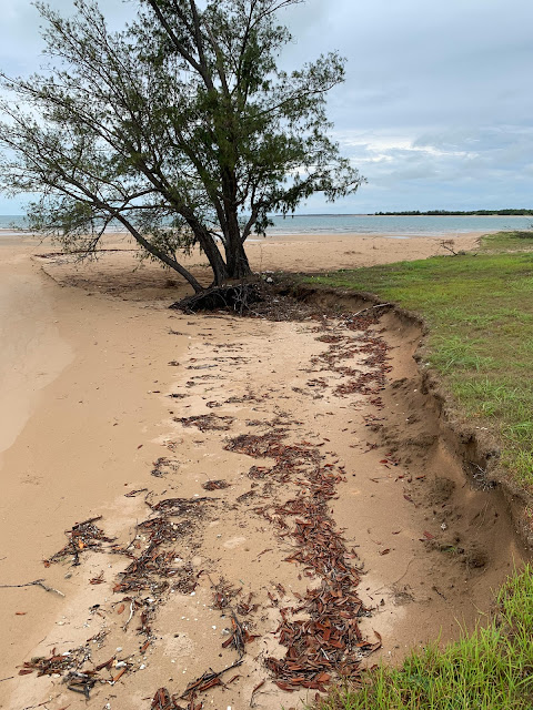
Regularly we are seeing scenes like the photo below where higher tides are eroding coastal casuarina trees. Many have fallen over and died.
I have to admit that I have found these scenes concerning so have been doing some investigation of my own.
The graph below shows the average sea level risings around the planet using information from many sea level measuring sites.
Unfortunately for many areas, including northern Australia, sea levels are not rising evenly. Some areas are rising several times quicker than others. Most will have seen videos of ice shelves and glaziers melting which contributes to rising sea levels. However apparently, there is more to this story than just meting ice. The oceans are absorbing around 90% of the increased heat energy caused by global warming and the rate of this absorption has been increasing over recent decades. Understanding these changes is a developing science however we know that the ocean currents amongst other factors, result in some areas of the oceans warming much quicker than others. This in turn contributes to the uneven rising sea levels around the globe.
The map of Australia below shows that sea levels are rising quicker in north Australia and up into Asia compared to other areas.
The image below based on satellite information shows that sea surface temperatures to the north of Australia are rising quicker than the global average - reds and yellows being the hottest. This increased temperature in turn seems to be causing a more rapid sea level increases in these areas.
.png)
The following are a few paragraphs from a NASA article on this subject explains this very well.
The two main reasons for uneven sea level rise being ocean dynamics and Earth’s uneven gravity field.
First, ocean dynamics is the redistribution of mass due to currents driven by wind, heating, evaporation and precipitation. For example, during La Niña events, sea level goes down because some rain that usually occurs over the ocean shifts to land, and the same phenomenon produces low latitude currents that redistribute seawater. Regional climate cycles, like El Niño and La Niña, and longer-term effects, like the Pacific Decadal Oscillation, change ocean circulation, which changes sea level.
Second, because the distribution of Earth’s mass is uneven, Earth’s gravity is also uneven. Therefore, the ocean’s surface isn’t actually a perfect sphere or ellipsoid; it is a bumpy surface. As the land-based ice sheets of Greenland and Antarctica continue to unload their mass (lose ice) from far above sea level and far from the tropics, that mass reaches the sea in the form of meltwater that is then redistributed along Earth’s gravity field.
Below are photos of some of our observations as we go about our ranger work.
This casuarina tree's days are numbered!
And this small casuarina tree below is just hanging on by one root.
The local ranger in the photo below is a member of the traditional owning group. He is in his mid 20s and tells me that he recalls camping as a boy and teenager at the site below when there were many casuarina trees and heaps of shade. Now, even the few trees that are left are being threatened.
Another area of change we are observing is around the coastal creeks and rivers. These tidal waterways have a mangroves growing along each side. Often there are areas between the mangroves and where the fresh water plants and trees grow where nothing grows - sometimes referred to as clay pans. These areas are too dry for mangroves and too salty for fresh water plants to grow. What we are observing is that mangroves are now populating these once bare areas. Another strong indicator of rising seas levels.
I have just returned from a few days in Katherine attending a ranger conference. We travelled by light aircraft charter. The track to Katherine from Croker Island and return took us over Kakadu and Nitmiluk (Katherine Gorge) National Parks. Most tourists see this country in the dry season. It all looks very different in the wet season! The next blog post will focus on this trip.
Nancy and Laura are visiting Alastair, Cathy and family this weekend on their sheep and cattle property near Ashford, NSW. I wish I could be there. Living remote has some advantages, and also some disadvantages - this being one of them.
Until the next post, take care and bless ya all.
.JPG)
.png)
.png)


Comments