Hi again
I spent some of my early years living near Chinchilla on the western Darling Downs in Queensland. It always puzzled me that people from Brisbane would refer to Chinchilla as being 'way out in western Queensland'. There used to be a T shirt promoting Chinchilla which had the words 'Chinchilla - Just East of Too Far West'. Chinchilla is just 250 kms from Brisbane yet around 1400 kms to the western Queensland border (135 kms west of Birdsville). So Chinchilla is actually still in south east Queensland!
My first visit to Birdsville was in December 1988, flying in a little Piper Comanche on my new private pilot's licence. In those days, before the terrorist attacks in America during September 2001, there were no high fences and coded gates at airports so one could park the plane directly opposite the Birdsville Hotel, refuel the plane and then walk across the road and 'refuel' the pilot and passengers.
Like a lot of western Queensland towns back then, Birdsville was struggling.
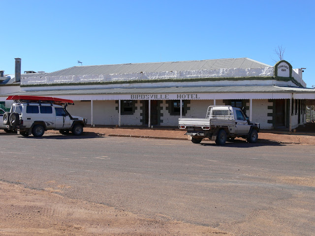
In May 2007, Nancy and I travelled up the Birdsville Track from South Australia and spent a few days in Birdsville - see photo below. There were now a lot of new buildings and the town seemed to have some life.
In 2025, Birdsville was quite a busy little town with many tourists coming and going.
Wirrarri or Birdsville was established in 1881. The first European who travelled through this area is believed to have been Charles Sturt in 1844.
Long before that, the Wangkangurru-Yarluyandi people lived on and cared for this land.
In 1860 the ill-fated Burke and Wills expedition camped in this area.
In 1879, 67 local Wangkangurru-Yarluyandi people were killed on The Bluff by police and pastoralists in response to the death of one stockman.This was reported to the Police Commissioner by the pastoralist on Warburton Creek Station.
For many years Birdsville's main market and supply centres were Adelaide and Port Augusta - Birdsville being just 750 kms from Port Augusta and 1000kms from Adelaide while being 1400 kms from Brisbane.
Birdsville, known originally as the Diamantina Crossing, is reputed to have sprung up around a rough depot constructed by general merchant Matthew Flynn in the late 1870s on the stock route from Boulia south to Adelaide.
Consequently, in 1881 a customs office was established in Birdsville to collect customs from cattle and goods crossing the border.
Between 1890 and 1960, thousands of cattle were driven along the Birdsville Track to southern markets, making Birdsville a crucial staging point.
The current day Birdsville Bakery tries very hard to keep the numerous flies outside. Additional to the sign on the door there is a fan mounted above the door blowing air down on people as they enter and leave.
The transport of goods to Birdsville today is via triple road trains. Less than 100 years ago the same job was done by camels - winter and summer, droughts ........
........ and floods.
Tom Kruse became the famous Birdsville Mailman. He operated the Birdsville Track mail run from 1936 to 1957, driving his Leyland Badger truck. He delivered mail and other supplies including general stores, fuel and medicine to remote stations from Maree in South Australia to Birdsville, some 325 miles (523 kilometres) away. Each trip would take two weeks and Kruse regularly had to manage break-downs, flooding creeks and rivers, and getting bogged in desert dunes.
The nearby Diamantina River has dropped significantly from the major flood levels a few months ago.
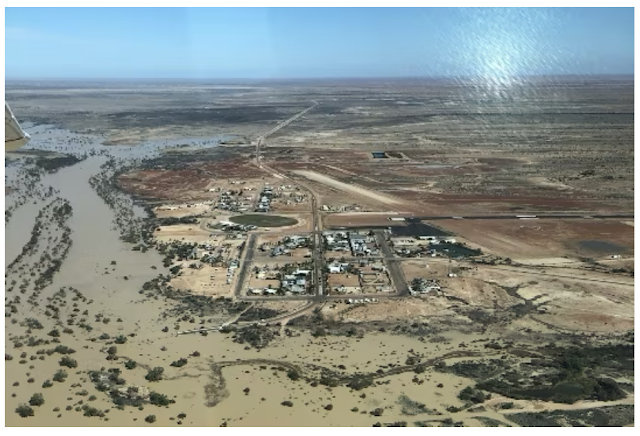
In the drone photo below (from a 2022 ABC News article) you can see the town of Birdsville with the Diamantina River in flood - looking towards the south west. The road disappearing off into the distance is the road west to the Big Red sand dune and the Simpson Desert. The road coming from the town and bending around towards the bottom left corner of the photo before disappearing into the flood river is the road to the east. A little out of town on this road is the turn off to the Birdsville track leading to Maree in South Australia.
In the drone photo below (from the Birdsville Hotel's website) the 2025 flood levels are higher than in 2022 - looking towards the south. The Birdsville nurses had rare water front views from their accommodation (top left corner of the town) and the water had inundated some of the caravan park (top middle).
In the Australian Inland Mission (AIM) Birdsville Museum, Nancy recognised the blood pressure measuring device below as she had used units just like this one back in the 1970s and early 80s.
And then a little later I saw this Codan HF radio - I used very similar units in Arnhem Land in the 1980s and 90s before there were any phone services in that area. So ...... having used both pieces of equipment in our younger years which now featured in this museum, we joked about whether this means that we should also be in a museum.
The artesian bore water at Birdsville comes to the surface under good pressure (no pump required) and at 98 degrees celsius. Part of Birdsville's power is generated via a thermal power generator. The photo below shows the water after it has been through the power station. From here it flows to a cooling pond and then the water is used for the town's water supply.
At Mt Dare Hotel, Nancy had bought a children's story book for Noah and Amelia based on a true story of a VW Beetle car named 'Onslo' that crossed the Simpson Desert - see book cover below.
During our day looking around Birdsville, we were surprised to came across the real 'Onslo'. Apart from some over size rear tyres, there does not appear to be any other modifications. The drive this two wheel drive vehicle across the Simpson was a mighty effort.
In my previous post I talked about the Big Red sand dune. This last week John Williamson did two special concerts at the very site where we had lunch a few weeks ago. See links below.
Anyway, tomorrow we are booked for a scenic flight over Lake Eyre, taking off just after first light.
Until then, take care.


Comments